The Democratic Spirit Trailside: Fire, Ire, and Public Lands
July 2023
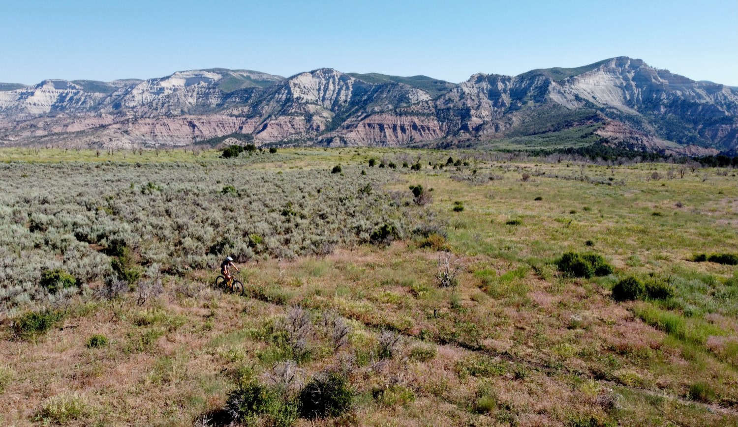
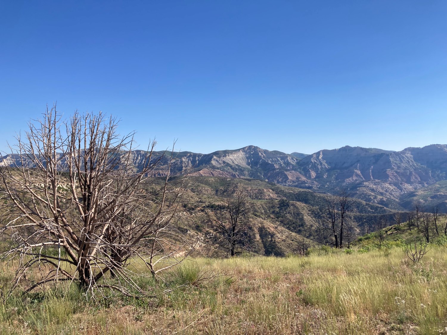
My first real venture back into the burnt area was on a shop ride. Once we arrived at the top of Cicada, the damage from the fire became apparent to either side of the trail, as well as the scarred and eroded vista. The Upper Book Cliffs, still looming taller in the distance, lacked their usual summer green, as many of the old growth juniper and pinyon were killed entirely. The sheer sides bore new gashes from recent mudslides. Around me, oakbrush and some grass reseeded in 2021 were just taking root in the loose soil. I took a deep breath as I threw on my Camelbak and took one more look at the changes before pedaling forward.
When the Pine Gulch Fire ignited by lightning strike, I was driving towards Fruita from Bozeman, Montana. This range of shorter mountains is composed of layers of shale and prehistoric matter, which give way to rolling, bentonite clay hills dented by drainages, then the valley floor. This low-lying range becomes more rugged beyond the phyllo pastry ridge, where it provides scrubby habitat to elk, mountain lions, black bears, and jackrabbits. The range is predominantly dry and rocky, lacking the density of the thousands of acres of beetle-killed pines that have burned across Colorado in recent years, which is why I was surprised to see a small, gray smoke cloud over the Book Cliffs as I drove eastward on I-70.
The week of my visit the growing mass of smoke hung in the dry, summer air over the north end of the Grand Valley. The cloud became a haze as I floated the Colorado River the day before driving back to Montana. The river was sluggish under the weight of drought summer and the air now smelled of smoke. After I returned to Montana the Pine Gulch Fire was named and grew for over two weeks, consuming acres of dry cheatgrass, junipers, pinyons, and rabbitbrush. My mother sent me blurry photos of the glow of the fire at night, then visible from the valley floor over five miles away. Over fifty cow-calf pairs were summered on my family’s Bureau of Land Management grazing permit, so we all monitored the fire with increasingly greater concern as it burned. These cattle remained out of reach of the blaze until one evening that strong gusts caught the fire at forty miles per hour and drove it furiously across canyons and up hillsides. Hundreds of acres burned overnight, including the entire grazing permit.
The next day Mom called. My family and other ranchers went back up to survey the damage once the canyon roads opened , finding the gullies and slopes black and dead as the mountains’ subterranean coal. All but the gnarled trunks of larger trees burnt to the ground. The fire caused minimal structural damage, burning in such a rugged area, but the ranchers who lost cattle in the blaze were dealt a shocking blow. When these ranching families most impacted by the fire returned in order to survey the fire damage, they stepped over intact birds that died mid-flight of smoke inhalation and were stung by dozens of displaced bees which emerged from the ashen ground. This small group of ranchers searched on foot through rugged terrain, still warm from the fire, for their missing cattle— some of which escaped the fire through an act of some tenacious instinct, but most of which were found, clearly having died in devastating, terrible conditions. These gruesome remains had to be documented via photograph in order to receive disaster relief compensation. From Montana, I found myself drifting helplessly through my days of teaching, trying not to think about this devastation relayed to me by family: the calves overtaken by fire alongside their mothers, and of my family bearing witness from the valley floor as the bright, flickering fringe fell over the Book Cliffs.
In the weeks that followed most of the western United States fell under that curtain: as ash fell like snow on car windshields in Fruita, the sky turned red over Oregon, Washington, and California. Loss abounded. Whole communities were burned. In Montana, Bridger Canyon lit up with flame, and my husband and I stood on a hill at a distance from the other gathering families at the park watching the flame through binoculars as it crept around the corner from the white ‘M’ overlooking Bozeman. Smoke season is a part of the yearly rhythm, but in 2020 wildfire became for so many communities a despicable prophecy that could not be outrun. Although part of a small group affected most by the Pine Gulch Fire, my family’s view of the future is now refracted through its light. The tenuousness of it all resonates with us all the more.
***
The Pine Gulch Fire is not the only devastation to sweep the Book Cliffs since settlers arrived in the region. This range, which sweeps from Eastern Utah to Parachute, CO, was the site of strong animosity between the cattle ranchers and sheepherders throughout the late 1800’s and early 1900’s. Shortly after the removal of the Ute from the region, many settlers arrived intending to graze herds on the land. During these conflicts, sheepherders were shot and wounded, and barbed wire was strung up and cut. In the 1894 Peach Day Massacre, over three thousand sheep were beaten to death by men whose connections to local ranchers could not definitively be proven. During other incidents, sheep were driven over the shale cliffs of the Roan Plateau and shot.
The Book Cliffs have also long been home to extractive industries. In the Grand Valley, agriculture and outdoor recreation take up much space on the valley floor, but the surrounding ranges house oil shale extraction and even some coal mining. Like other extractive communities, the Grand Valley has endured some serious boom-bust cycles, including an industry-related recession in the 1980’s which reduced jobs in the county by 20 percent. With over twenty years of hard drought, the agricultural sector in this community has clearly weathered challenges beyond the Pine Gulch Fire. Outdoor recreation is a relatively new industry here, and the beginnings of singletrack building in Fruita were not without their own legal or social tensions. The short lifetime of public land as we now recognize it has always been contentious.
As a native and longtime resident of the Grand Valley, I find David Foster Wallace’s concept of the Democratic Spirit to be a guiding light when it comes to my own preconceptions and priorities regarding land use. In his essay “Authority and American Usage” he defines his “Democratic Spirit” as “one that combines rigor and humility, i.e., passionate conviction plus a sedulous respect for the convictions of others...you have to be willing to look honestly at yourself and at your motives for believing what you believe, and to do it more or less continually.” I find Wallace’s Democratic Spirit so helpful because I’m privy to both discussions about the trail damage caused by cattle and the challenges of food production in the Grand Valley, as someone who grew up on a working farm and ranch in Fruita. Grazing on public land receives plenty of criticism from trail users like mountain bikers and those concerned about the impact of cattle on desert ecosystems, and yet we literally follow in these animals’ footsteps. Cattle, especially when overgrazed on an area, can damage soil and plant life and degrade watersheds, but public land grazing, especially when managed conscientiously with the landscape in mind, can also lessen the amount of Colorado River irrigation water used by farmers and ranchers on their own farmland. During a remarkably damp spring like the one we just had, cattle can also leave singletrack indelibly pockmarked, giving mountain bikers another good reason to see themselves as the superior trail users. These seemingly intractable conflicts require the kind of nuanced, careful consideration granted by Wallace’s Democratic Spirit, which he considered “up there with religious faith and emotional maturity and all those other top-of-the-Maslow-Pyramid-type qualities that people spend their whole lives working on.” Wallace goes on to admit that “a Democratic Spirit's constituent rigor and humility and self-honesty are, in fact, so hard to maintain on certain issues that it's almost irresistibly tempting to fall in with some established dogmatic camp and to follow that camp's line on the issue and to let your position harden within the camp and become inflexible and to believe that the other camps are either evil or insane and to spend all your time and energy trying to shout over them.” As cyclists and as land users, it doesn’t hurt to check ourselves: not just on our preferences regarding bike or trail, but on our preconceptions about who appreciates or uses land the best. Although introduced here in a discussion of language and authority, this concept lends itself to understanding other land and trail users. Especially after a season with even more than usual cattle damage on some of Fruita's trail sections, it can be difficult to consider the other point of view, driving home the actual challenge of maintaining this Democratic Spirit. But the questions of climate change, public land use, and ethical, ecologically sound food production demand rigor, humility, and self-interrogation from us all, whether we are trail users or food producers. The Democratic Spirit cannot tolerate interhuman or ecological violence. This approach might be our only way forward without shutting each other out entirely.
What I can tell you, especially in the wake of the Pine Gulch Fire, is that cattle are far more than dollar signs wrapped in hide to the ranchers who raise them. They are fellow travelers on the landscape, and we do the best by them that we possibly can. While overgrazing is the textbook example of the tragedy of the commons, ranchers are also incentivized and educated against overgrazing in order to protect the land and their own interests into the future. Mesa County farmers and ranchers are increasingly aware of environmental impact and many are implementing practices like no-till planting, converting irrigation pipelines to underground, gated systems, and soil moisture testing. When grazing cattle on BLM permitted land, cattle are counted and monitored in order to meet agency standards to avoid the past mistakes of overgrazing. Growing up on the ranch, I learned early to track the movements of bears, turkey, quail, and coyotes, and lament the decline in monarch butterflies and ring-necked pheasants in the area— perceiving the world in these systems of food and mutual growth. I have already observed a shift in ecological imagination in the agricultural community based on this reciprocity, as well as planning in earnest for rising temperatures, water scarcity, and other climate-related long term issues.
The self cannot be completely omitted if one truly wants to hold to the Democratic Spirit of rigor, and humility, and self honesty— it must be worked through like any other problem, rather than pointing instant blame on other parties. Despite apparent differences, I know that both local food producers and mountain bikers share many ecological concerns. We’re all affected by precipitation and weather, we can all be amateur soil scientists or geologists, and we all take note of the flora and fauna that make this region so special. We can all notice the shrinking populations of mule deer and ring-necked pheasants in the North Fruita area, and the declining insect populations. Growing up on a working farm and ranch, and mountain biking my home landscape, I see my home region in seasons, shadows, and living things: the changing height of corn and triticale, the swoop of a hawk over freshly cut hay, the lemonade pink sunset on the Book Cliffs, the rise and fall of the Sego lily and Indian paintbrush, and the wild skipping of lambs. Until now, the cattle grazing on the mountain was a part of this great pattern of one constellation rising and another falling. The cows lost in the wildfire are not dollar signs wrapped in hide, nor are they cartoonish images of a hamburger on hooves, but rather fellow travelers of the landscape with whom we have a reciprocal relationship. We move and care for the cattle and they do their part, and experience some of the goodness of being while they’re at it.
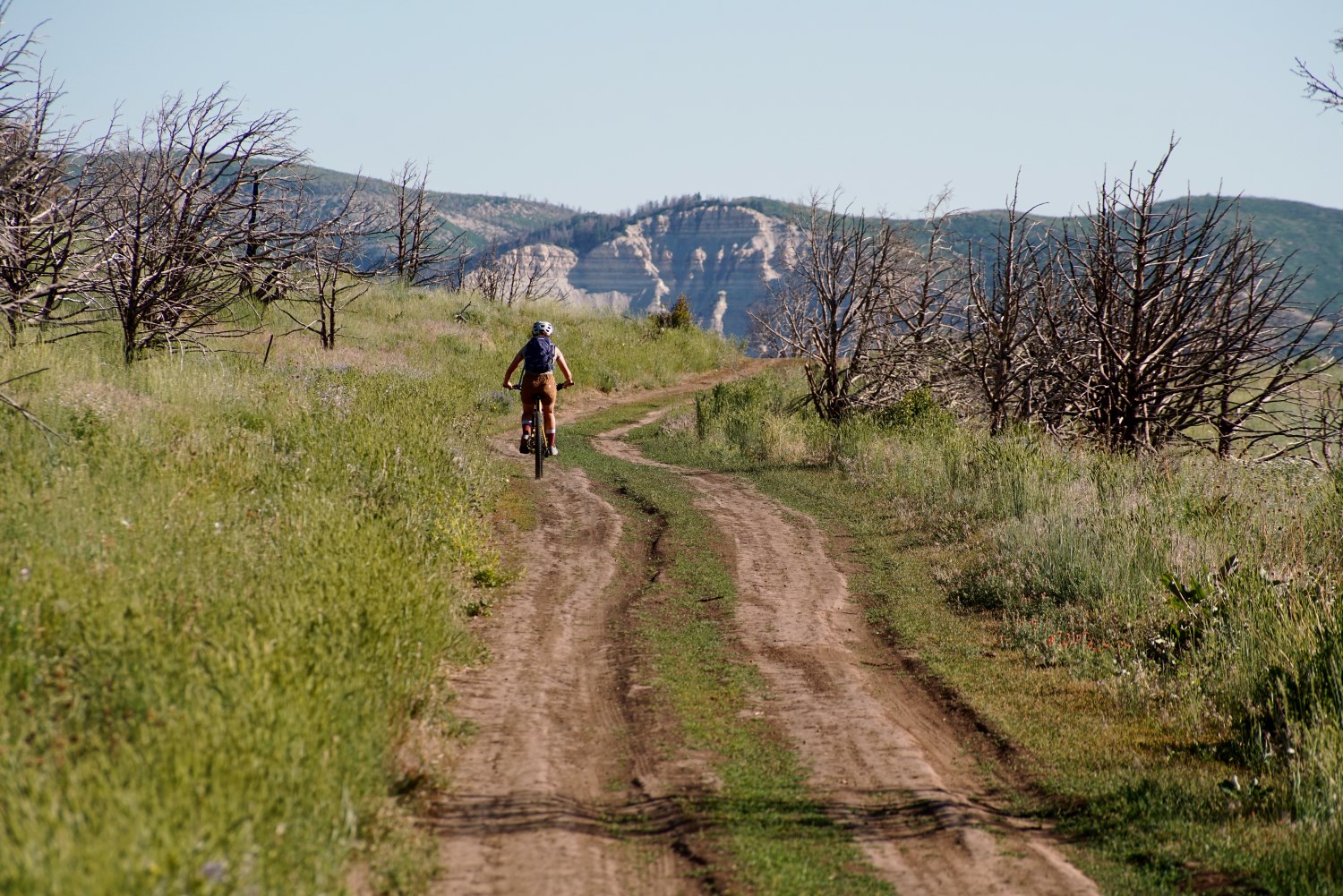
Trail users and gravel riders can also experience these cycles of life and seasonality, and the overlap of different land uses while they traverse the Book Cliffs and other parts of the Grand Valley. To explore the Book Cliffs beyond the 18 Road trails, mountain bikers will want to ride the intermediate/advanced Sarlacc trail first. The newer Upper Book Cliff trails bear more signs of fire damage and moto use, and a big day up there is more about adventure miles than riding pristine singletrack. However, adventure riding is often just as much about cultivating a sense of place over the miles as it is about momentum and endurance, and often reinforces the mindset of “rigor and humility” which Wallace endorses. Always respect the wildlife closures from December 1-May 1 for these upper Book Cliff trails.
Due to moto use, parts of these trails will hold pockets of fine dust which can complicate sudden maneuvers, but these uppermost trails will also give the largest views of fire damage. For a more rugged ride, 4 Road northward becomes Baxter Pass to the west of 139, and the long climb could make a good hardtail adventure (this one might be a little too chunky to have a good time on a gravel bike). This route will take riders past the ghost town of Atchee, which was once owned by the Gilsonite Company. No matter where you ride in the Book Cliffs, expect to consume all of your water.
For riders looking for an all-morning gravel ride with iconic Book Cliff vistas, the Wild Horse gravel loop near De Beque offers geologic intrigue and the possibility of viewing wild horse herds from afar. Closer to Grand Junction, gravel riders can access the ghost town of Carpenter off of 27 ¼ Road. All of these adventure rides, whether singletrack or dirt road, offer opportunities to consider the lives and work of people different from ourselves: the Ute communities which were displaced from the region, the many waves of settlers in the Valley, and those who we pass by while traversing public land, whether they are hard at work or fellow recreators.
Nearly three years after the Pine Gulch Fire, it remains clear to me how much using public land and living with fire both require self-interrogation and accommodation for nuance. Losing property, livestock, or a livelihood to fire are horrible realities for so many. Fire itself has been intractable in North American ecologies for centuries, and can be an important part of managing ecosystems long term. Unlike a smaller, seasonal fire, the Pine Gulch Fire burned extremely hot and destroyed a high percentage of older growth trees. Since then, the landscape burned by the fire has experienced mudslides and massive erosion in some areas (some visible up 16 Road and Hunter Canyon), which in turn reduces the long term benefits of the BLM’s native flora reseeding efforts from 2021. The path to regrowth is long. Coal seams, abandoned mining infrastructure, and the active natural gas pads in the lower Book Cliffs, along with the presence of hunters, mountain bikers, off-road enthusiasts, ranchers, and naturalists demonstrate how many different paths have converged in the range. We can do our best as land stewards and neighbors to converge peacefully among the rabbit brush and the twisted junipers of the Book Cliffs, especially if we grant each other the dignity of listening and self interrogation.
Megan Vorse works in Sales at Over the Edge. She holds an MA in English from Montana State University, and rides a Juliana Joplin and Why Cycles R+.